Saturday, August 24, 2013

Lafayette Park, Norfolk, VA

I had to do a greyhound home visit in Norfolk this morning, so thought I would look for a nearby park for us to explore. I decided to go to Lafayette Park on Granby Street right next to the Virginia Zoo.
Lafayette Park is one of the oldest parks in the City of Norfolk. In 1899, the city officially opened it, and a year later, the park began acquiring animals to put on exhibit. By 1901, the Lafayette Park zoo had acquired over 200 animals including mammals, reptiles and birds. We could see one of the animals, some kind of an African herd animal, through the bamboo but it's very hard to see in our photo. It's kind of a light brown blob on the right hand side of the photo below!
 In the early 1900s, visitors could drive their cars through the park and look at the animals. It wasn't until the late 1960's when the zoo was fenced off from Lafayette Park.
The park is very shady, with lots of paths to walk on. It also has a playground, basketball courts, soccer field, tennis courts, picnic pavilions and rest rooms. There are a lot of homeless people at this park--I don't think I'd feel safe after dark--but on this bright, sunny morning it was OK.

If you walk along the north edge of the park and zoo, there is a boat ramp to the Lafayette River. We met several gentlemen fishing for croaker at the boat ramp.
Sammy and PG weren't interested in going into the river. I guess the day wasn't hot enough for them to want to splash around.
The Lafayette River was originally known as Tanner's Creek. Tanner's Creek was renamed the Lafayette River at about the same time Lafayette Park was established. River and park were named in honor of the Marquis de La Fayette, a French Army officer who became a popular American Revolutionary War hero.

J'aimerais que tu sois là (wish you were here!),
Joyce
Sammy & PG


Saturday, August 17, 2013

Newport News Park, Newport News, VA

Just off Interstate 64 at Exit 250B--you will find Newport News Park. What a treasure!
This 8,000 acre park is one of the largest municipal parks in the country. It is beautifully maintained with manicured landscaping all around. The picnic shelters all have nice pavers and look more like  outdoor cafes rather than a picnic pavilions.
We made a wrong turn when we first got there and ended up by the Disc Golf course. We went on a short walk past an old Japanese tea house. It is surrounded by a stream with a waterfall. I've been looking for a path with a waterfall--who knew there was one right in Newport News!
We left that area and drove a little farther into the park to the Discovery Center.
I recommend going here to start out. There are a number of trails that start from this point. For history lovers, Newport News Park is the site of some of the best preserved Civil War fortifications, earthworks and redoubts in Virginia, and is a designated stop on the official Virginia Civil War Trails network.  There are signs on the trails explaining different battles.
The path is sand or gravel covered and level so it's easy to walk on. There are hardly any elevation changes but there are lots of roots across the path that you have to watch out for. We walked on the Discovery Center trail.
We came across some wildlife--a mole poked its head out at the wrong moment as we were walking by. PG snatched it up, shook it and killed it. At the end of the trail, we came across 4 deer. Hounds that instinctively want to chase game are very excited when they come into contact with deer! And the deer are so used to people--they didn't even run away. An exciting end to the walk!
When we go back, we're going to walk on the White Oak Trail. It's a 2.4 mile trail around the lake.  Maybe we'll do that in the fall when the leaves are changing--it should be beautiful!

Wish you were here!
Joyce
Sammy & PG


Sunday, July 28, 2013

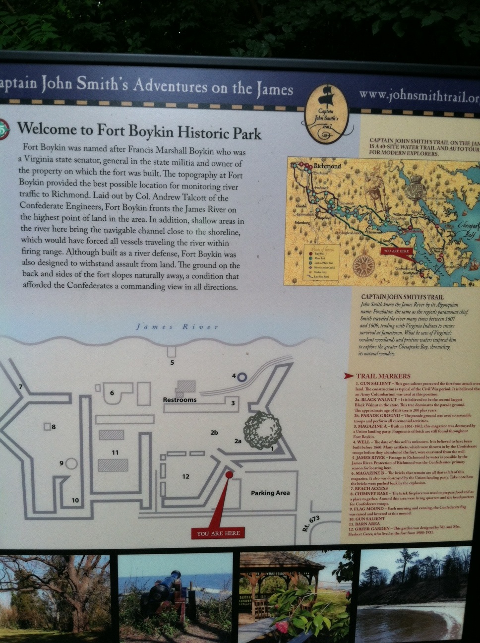
Fort Boykin Park, Smithfield, VA

Today we ventured to Smithfield to go to the very secluded Fort Boykin Historical Park. How to get here? From downtown Smithfield--head northwest on Church Street, go past the Smithfield Packing Plants, turn right on Blounts Corner Road, turn right on Morgart's Beach Road (which is a dirt road) and in about 2 miles you'll find the park on the left.
The parking area and the picnic area are together.
There is a sign that explains a little history of the park. It's been around since1623 when a fort known as the Castle was constructed to protect the Jamestown colonists from Native Americans and raiding Spaniards. Atop a bluff overlooking the James River, the site’s commanding view makes it a keen observation point. Fort Boykin was re-named during the Revolutionary War after Maj. Francis Boykin, a local merchant who served on Gen. George Washington’s staff and who owned the property.
Between June 1861 and May 1862, the Confederate Army rebuilt the fort as a part of their defensive system. It was one of in a series of earthworks designed to prevent inland invasion by the Union, whose buildup at the mouth of the James River posed a severe threat to Richmond, the Confederate capital. So the entrance to the park is up over some very steep steps that go over the earthworks. Greyhounds normally have trouble with steps that steep--but mine took the steps in a few leaps.

There really are no paths, other than the concrete walkway down to the beach area. The whole park is very shady with lots of old trees so it's a nice place to walk in the hot summertime.
The beach on the James River is very secluded, too. There was a man swimming with a lab and a Rottweiler--they were the only ones we saw during our whole time there.
Sammy and PG enjoyed going into the water for a dip. I probably could have let them go swimming--but I'm not sure how well they swim.

Fort Boykins is on the Virginia Birding and Wildlife Trail. It is part of the eBird System, the bird database run by the Cornell Lab of Ornithology and the National Audubon Society. And, Fort Boykin is home to the commonwealth’s second oldest black walnut tree. This tree, over 200 years old, has been named to the Remarkable Trees of Virginia Project.

Wish you were here,
Joyce
Sammy & PG


Monday, June 24, 2013

Riverwalk Trail, Rock Hill, SC

This weekend we went to visit family in South Carolina, just over the border from North Carolina, very close to Charlotte. I found this new trail for the dogs.
It is a part of the Carolina Thread Trail system. The Carolina Thread Trail system is a series of trails throughout the Carolinas open to the public that connects people, cities and towns. The Riverwalk Trail is in a housing development--but right along the river--keeping that portion of the development open to all.
The trail starts out at a canoe/kayak launch. It is easy to find--right off Cherry Road in Rock Hill.
This is a beautiful trail along the river. It's paved and has a few elevation changes--but pretty easy to walk. Mountain bikes go on the trail, too--so you have to be aware of them passing.
There is a 10 mph speed limit, though, Sammy! No running!
All along the trail, you can view the Catawba River. People are canoeing and kayaking. Lots of birds.
The trail goes 4.25 miles out and back; it doesn't loop around. We walked a mile in and then turned around and walked back out because it was humid and the dogs were hot.  The trail is marked every 1/4 mile so you can decide when to turn around.

On the way back, Sammy and PG went into the river for a dip. They loved that part of the walk!


 Sammy really enjoyed the water!
http://www.youtube.com/watch?v=TCEh8B6qQOQ

I have to add another note about our trip. I tried to walk at Cherry Park, also in Rock Hill. I walked there in December the last time I visited. But this time, when I walked at Cherry Park I was stopped by one of the park rangers and told there was a "one dog per person" rule. Since I had more than one dog, I had to leave! Isn't that a crazy rule? The ranger said the people who have more than one dog never pick up after their dogs. I pulled out a handful of poop bags from my purse! Then he said that people are afraid of dogs and when someone walks more than one dog, it's really scary. I said, Well, I'm going to have to put this on my blog! One dog per person. He said, Please don't write anything bad about our park on your blog! So, if you only have one dog--Cherry Park is a nice place to walk. But if you have more than one dog, go to Riverwalk Trail!

Also while we were in the Charlotte area, we went to several dog friendly restaurants. One was Toast Cafe. This cafe was in the Ballentyne area of Charlotte. They are only open for breakfast/brunch from 8am till 2:30pm.
The dogs were welcome on the patio. The waitress brought water for both dogs. And refilled it at the same time as she refilled the other waters at the table!
Overall, Charlotte, NC and Rock Hill/Fort Mill, SC are very dog friendly areas!

Wish you were here!
Joyce
Sammy & PG

Saturday, June 15, 2013

Aroma's, Williamsburg, VA

This morning my friend, Lesa, and I went to the Williamsburg Farmer's Market and afterwards we went to Aroma's.
I recommend parking in the Prince George Street Garage (P1) for $1 per hour. Walk out the side doors and turn right--Aroma's is right there at 431 Prince George Street.
This is such a dog friendly place. There are water bowls along the patio--which is so nice on a summer day! Dogs are at almost every table on the patio. Of course, you still have to have an extra person to go inside and order for you.
We went for breakfast and had the Garden Veggie Scramble and Mimosas.  Delicious! But Aroma's also serves lunch and dinner--so you can go at any time! They roast their coffee in-house 7 days a week and have a huge menu of hot and cold drinks.
PG and Sammy laid under the table on their pads. PG was very close to the door so she had a good view of everyone going in and out. "Are those greyhounds? Are they rescues? They're beautiful!" was the refrain for the day!

Aroma's also has a location in Newport News at City Center near the fountain. It's also dog friendly but has a different ambiance and feel than the original location in Williamsburg.

Wish you were here!
Joyce
Sammy & PG


Monday, May 27, 2013

Kiptopeke State Park, Cape Charles, VA

Today I met up with some friends at Kiptopeke State Park. Kiptopeke is three miles from the northern end of the Chesapeake Bay Bridge Tunnel on Route 13. Turn west on Route 704; the park entrance is within a half mile. There is a $12 charge to cross the Chesapeake Bay Bridge Tunnel one way; and $5 to return. Although one of the ladies in the toll booth does give seagull shaped dog cookies to you if she sees dogs in your vehicle!
There is also a $4 charge to park since it is a state park. Kiptopeke has lodges, yurts and a few trailers for rent; and  all are pet friendly for an additional $10 per night.
But of course, we were there to walk on the trails. The trails are level and easy to walk on. Take a trail map with you, though--there are 6 or 7 different trails and they don't all loop around back to the starting point.
There are more than four miles of trails. We walked through upland hardwood forest along Baywoods and Songbird Trails. People can also bike here. There are many, many birds here. This refuge is a stop on their migratory path.
Sammy did not want to stay on the trail; and he was covered in ticks by the end of the walk! He had at least one tick between each toe on all four feet; as well as several ticks on all four legs. Dozens of them! After the walk we sat under a shade tree and tried to get them all off of him.
We drove into Cape Charles, a few miles north of the park, after our walk to have a little picnic. We found a shady place to sit down and purchased a few sandwiches from Kelly's Pub as take out.
We also spent some time at the Cape Charles War Memorial to remember the men and women who died while serving in the United States Armed Forces because it was Memorial Day.

Wish you were here,
Joyce
Sammy & PG


Wednesday, May 15, 2013

Ball's Bluff Battlefield Regional Park, Leesburg, VA

Over the weekend we went north for the Grapehound Wine Tour. On Sunday, the greyhounds took a walk at the Ball's Bluff Battlefield Regional Park. To get there, take Route 7 west towards Leesburg, then Route 15 Bypass north. Turn right on Battlefield Parkway and left on Ball's Bluff Road. Travel through a housing plan and the park is located at the end of the street.
We were fortunate to have Jim Morgan, Chairman of the Friends of the Ball's Bluff Battlefield, give us a personal talk about the Civil War battle before the walk through the park.
There were about 20 greyhounds and their owners there for the walk.
PG and Sammy were ready to go! It was kind of chilly. And the pollen was miserable! Everyone's eyes were watering and sneezing all around. Even the dogs.
Finally the talk was over and we were on the trail! I am nowhere near as versed on the subject of this battle as Mr. Morgan--but I'll try to give you a rough overview. The battle at Ball's Bluff was one of the first battles of the Civil War and was an accident, not a planned attack. Union Brig. General Charles Stone took action against the Confederate troops because he was given faulty intelligence from a recon patrol. The recon patrol reported that a Confederate camp sat in a field but it was really just a row of trees. General Stone had his men maintain their position near Ball's Bluff; and he also ordered more troops across the Potomac River and put Colonel Edward Baker in command. The Confederate soldiers noticed the big troop movement--and this was also their back yard so they had a kind of home field advantage. The fighting began around 3pm on October 21, 1861 and raged almost non-stop until dark. The Confederate soldiers had a clear advantage and they pushed the Union Army back towards the bluff. 223 were killed, including Colonel Baker, who was a lifelong friend of Abraham Lincoln.
There is a tombstone at the spot where they think Colonel Baker was buried.  Colonel Baker was a US Senator from Oregon and was the only US Senator ever killed in battle.
The Union Army placed "mountain howitzers" on the knoll overlooking the field, but these were captured by the Confederate soldiers.
The cemetery at Ball's Bluff is a national cemetery, the third smallest national cemetery in the country. Although there are remains of 54 people in the cemetery, only one soldier was ever identified.

If you are interested in learning more about the battle, you can go to the Ball's Bluff Regional Park's website.

The park is a very pretty place to walk with views over the Potomac along the bluff. We enjoyed the interpretive walk with Mr. Morgan but now PG is ready to leave!

Wish you were here,
Joyce
Sammy & PG